


This is the Oeschinensee, one of the most beautiful mountain lakes in the Swiss Alps, and one of our favorite stops during our 9-day inn-to inn hike through the Berner Oberland. The hiking day is a big one. We begin in a remote valley called the Kiental and climb 1,370 meters (nearly 4,500 feet) to the 2,778 meter-high Hohtürli pass. A side trip at the pass takes us to the dramatically situated Blüemlisalphütte (2,840 meters) which serves one of the best Käseschnitte (Swiss cheese on white wine-drenched toast), that you’ve ever tasted. Accompanied by an optional (but highly recommended) glass of Schnapps, the Käseschnitte is especially warming on a rainy or snowy afternoon! Following lunch, we descend past the beautiful Oeschinensee (Oeschinen Lake) and finish in the tranquil Swiss village of Kandersteg. The hiking distance for the day is around 17 kilometers/10 miles with 1,450 meters/4,757 feet of ascent and 1,700 meters/5,577 feet of descent.
Mont Collon is one of my favorite mountains in the Swiss Alps
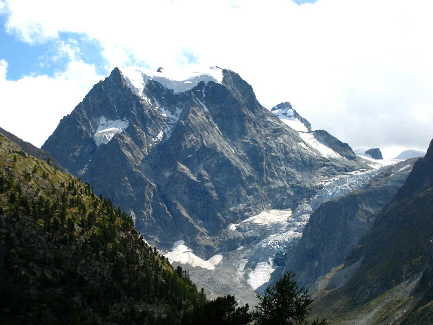
Do you recognize this mountain? It's one of my favorites yet, surprisingly, it seems to get very little exposure in the media (print, digital, social or otherwise). It's kind of an underdog, and I'm not sure why. It has everything a nice looking mountain could want—a triangular shape, tumbling glaciers, an imposing North Face, lots of rock. There's even a real face within the North Face. Can you see it? Anyway, I love it. The name of the mountain is Mont Collon, elevation 11,932 feet (3,637 meters). Mont Collon is located in the Pennine Alps in the canton of Valais, Switzerland. The glacier that you see tumbling down from the right is called the Glacier du Mont Collon, which flows into what remains of the Bas Glacier d'Arolla. Sadly, warm weather over the years has taken it's toll on the ice. You can see this lovely mountain when hiking the famous Haute Route from Chamonix, France to Zermatt, Switzerland. This view dominates the skyline as you look south from the village of Arolla, elevation 6,555 feet (1,998 meters).
Pic of the Day: Crossing the Meidpass on the Hiker's Haute Route
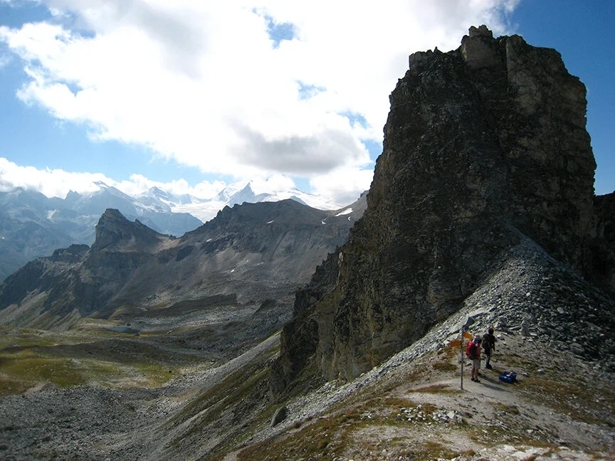
Here’s a photo of the Meidpass, elevation 9,150 feet (2,789 meters). This pass is the most direct route between the alpine villages of Saint-Luc and Gruben, and it also marks the linguistic divide between French and German-speaking Switzerland. Many hikers cross the Meidpass every summer during their quest to complete the Hiker's Haute Route, one of the most famous long distance hiking trails in the Alps. There's also a scenic alternative to this pass called the Col de la Forcletta which ventures further south from this point, then curves back north into the remote Turtmanntal (Turtmann Valley). The Forcletta is an outstanding option. It takes you right up close to, and offers phenomenal views of, some of the tallest mountains in the Swiss Alps including the Matterhorn.
Spotlight on our NEW Grindelwald, Zermatt & Chamonix Hiking Tour—Part 2

Sunrise on the Matterhorn above Zermatt, Switzerland.
Note: This is part 2 of a 3-part spotlight on our Grindelwald, Zermatt and Chamonix Hiking Tour. To read part 1 please click here.
In our previous post we introduced our new Grindelwald, Zermatt & Chamonix hiking tour, a hike that we also refer to as the Eiger, Matterhorn & Mont Blanc.
After a bit of inn-to-inn hiking below the Eiger, we hop on a Swiss train and transfer to the internationally renowned destination of Zermatt, a vibrant alpine village nestled at the base of one of the most identifiable mountains in the Swiss Alps—the Matterhorn.

The Matterhorn region in Switzerland is a paradise for hikers. Hiking trails lead everywhere, connected by a sophisticated network of cog railways and aerial lifts.
Like the Eiger, the Matterhorn is a mountain that everyone should see at least once in their lives. The perfect pyramid shape of the peak makes the Matterhorn an absolute joy to behold and photograph. Also like the Eiger, the Matterhorn has a formidable north face—one of the six great north faces of the Alps. As we mentioned in our previous post, north faces are special because they’re typically the coldest, darkest, iciest and most difficult routes to climb. It was this climbing challenge that originally brought the first adventure seekers to the Matterhorn. As luck would have it, however, the very characteristics that make north faces challenging to climb also give them a dramatic and beautiful appearance. The climbing community may have put the Matterhorn on the map, but artists, writers and aesthetes have been flocking to the Matterhorn to view its stunning north face ever since. Mark Twain, for example, enjoyed a very agreeable stay beneath the Matterhorn in August of 1878 and wrote about his experience in “A Tramp Abroad” in 1881.
If not for the Matterhorn’s distinctive shape, the mountain would probably get lost amongst the surrounding peaks and glaciers. The Matterhorn is part of a mountain range called the Pennine Alps, which is the highest mountain range in Western Europe. From the Gornergrat, a scenic rocky ridge above Zermatt, a person can see nearly 30 peaks above 4,000 meters (13,000 feet) high including the Matterhorn and the Dufourspitze. The Dufourspitze at 4,534 meters/15,203 feet above sea level, is the highest summit in Switzerland, and it’s one of the ten main summits of the Monte Rosa Massif, the second highest mountain in the Alps. (Mont Blanc in France is the highest and the final stop on our Grindelwald, Zermatt, Chamonix hike.) The mountain complex adjacent to the Matterhorn is also home to the Gorner Glacier, the second largest glacier system in the Alps. (The Aletsch is the largest in Europe. See our previous post.)
With all of these mountains and glaciers, it’s only natural that the Matterhorn region would become a paradise for hikers and outdoor adventurers. Hiking trails lead everywhere, connected by a sophisticated network of cog railways and aerial lifts including the Klein Matterhorn, the highest ski lift in Europe 12,830 feet.

The old town of Zermatt with its blackened timber chalets, slate rooftops and cobblestone streets is a joy to explore.
The history of the Mattertal, the valley that Zermatt occupies, goes back centuries, so there’s plenty for history lovers to take in too. A contemporary underground museum in town covers the region’s history from its agricultural past to the tourism-driven present, and the cobblestone streets and ancient sunbaked chalets are a joy to roam. For train lovers, the Brig-Visp-Zermatt Railway (BVZ) is the gateway into town. The BVZ is a metre gauge rack railway which first brought rail service to Zermatt in 1891. Also featured in our Grindelwald, Zermatt & Chamonix hike is the Gornergrat cog railway, the world’s first fully electrified cog railway which opened in 1898. The views from the Gornergrat will knock you off your feet!
The next stop on our Grindelwald, Zermatt & Chamonix hike is Mont Blanc, which we explore in Part 3.
Spotlight on our NEW Grindelwald, Zermatt & Chamonix Hiking Tour—Part 1

The Eiger as seen from the Hotel Bellevue Des Alpes at Kleine Scheidegg, Switzerland.
Note: This is part 1 of a 3-part spotlight on our Grindelwald, Zermatt and Chamonix Hiking Tour.
This last month has been busy! Along with the new Swiss Alps ski trip that we introduced in May, we also designed a hiking tour for a 30-something couple that asked us to put together a self guided hike in Switzerland and France. Like the skiing guests, this couple had a few criteria. First, they wanted to see the most stunning mountains in the Swiss and French Alps. Second, they wanted a hearty dose of luxury since this is a special occasion and they don’t get to hike in the Alps every day. Third, they only have a week available, so they wanted maximum value for their time. This couple was also fine with a little busyness in exchange for WOW views. So we mixed everything in our magic beaker and voila, the result is our new Grindelwald, Zermatt & Chamonix hiking tour, a hike we also refer to as the Eiger, Matterhorn & Mont Blanc.

The mountains surrounding the Eiger are stunningly beautiful. This is the view from the carless village of Mürren. From left to right, the mountains in this photo are the Eiger, Mönch and Jungfrau.
Full disclosure: The towns of Grindelwald, Zermatt and Chamonix, and the Eiger, Matterhorn and Mont Blanc summits that anchor them, are not “off the beaten path.” They’re not “hidden gems,” nor are they the “greatest places you’ve never heard of.” These locations are not “the next big thing” because they ARE the thing, and they played a pivotal role in the history of modern alpine tourism. Mont Blanc, for example, has been attracting alpinists and adventurers to its summit since the late 1700s. The Matterhorn, to cite another example, welcomed famous authors and adventure-seekers like Mark Twain in the late 1800s. Put another way, mountain tourism is what it is today because of these destinations.
So why go then, in this age of endless quests to escape the crowds and find the next best undiscovered spot? The answer is simple. The Eiger, Matterhorn and Mont Blanc are three mountains that everyone should see at least once in their lives. Famous places are famous for a reason, and you’ll feel like you did something special if you stretch your legs along the slopes of these famous alpine giants.
Let’s begin with the Eiger, located in the Bernese Alps (Berner Oberland) of central Switzerland in a sub region of mountains called the Jungfrau. The Eiger is famous because it’s beautiful, and it’s beautiful for a number of reasons. First, the Eiger has the biggest north face in the Alps. North faces are special in the world of mountaineering because, facing north, they are shielded from the sun’s warming rays and are typically the coldest, darkest, iciest and most difficult routes to climb. The Eiger’s north face, referred to locally as the Nordwand, is one of the most formidable in Europe, towering 6,000 feet above the surrounding countryside. The Eiger is also part of a much larger group of mountains and glaciers with notable peaks like the Mönch, Jungfrau, Wetterhorn, Schreckhorn, Grosses Fiescherhorn and Finsteraarhorn. This last peak is the highest mountain in the Bernese Alps at 14,022 feet/4,274 meters. In the center of these mountains exists a fantastical world of glaciers including the largest glacier in Western Europe, the Aletsch.

The idyllic Lauterbrunnen Valley, Switzerland which has inspired artists and writers for centuries. The valley boasts 72 tumbling waterfalls.
All of this rock and ice has a profund effect on the surrounding landscape. The lower elevation countryside is well-watered which makes for a fairytale land of flower-filled meadows, green grass, bubbling streams, cool pine forests and misty waterfalls. It’s a land of profound beauty and inspiration. The famous poet Johann Wolfgang von Goethe composed "Song of the Spirits Over the Waters" while visiting Staubbach Falls, one of 72 waterfalls in the nearby Lauterbrunnen Valley. In addition, the elevation change of the region is striking, which makes for incredible photographs. Interlaken, for example, the jumping-off point for the region, sits 11,000 feet (3,401 meters) LOWER than the summit of the Eiger. The views from the lowlands to the highlands are stunning!
Finally, if you like historic trains and “typically Swiss” architecture, then there’s no better place to explore than the Swiss countryside surrounding the Eiger. The Brienz Rothornbahn steam-powered narrow gauge rack railway (opened in 1892) huffs and puffs above the Brienzersee (Lake Brienz) and offers panoramic views of the entire Jungfrau mountain range. The electrified Schynige Platte rack railway (opened in 1893) departs the village of Wilderswil and climbs at a leisurely 7.5 mph (12 kph) to a mountain-top vantage point that magnifies tenfold the view of the Eiger, Mönch and Jungfrau peaks. The Wengernalpbahn (opened in 1893), touted as the “longest cog railway in the world,” connects the villages of Lauterbrunnen and Grindelwald and carries passengers past idyllic wooden chalets and mountain pastures to the very base of the Eiger at a historic railway station called Kleine Scheidegg. At Kleine Scheidegg, guests descend the train and crane their necks back to examine the Eiger’s 6,000 foot-tall Nordwand. Last, but not least, the Jungfaubahn (opened in 1912) departs Kleine Scheidegg and carries passenger INSIDE the Eiger, eventually dropping them at the Jungfraujoch, the highest railstation in Europe servicing the eight highest railroad in the world.
A person can easily spend a week or more hiking the countryside that surrounds the Eiger, but our new Grindelwald, Zermatt & Chamonix hiking tour also explores the Matterhorn and the region of Mont Blanc which we’ll explore in part 2 and part 3 of this post. Stay tuned…